Land Use Change in Iowa
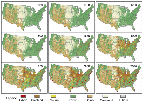
Land use change in Iowa, predominantly driven by agricultural expansion, urbanization, and infrastructure development, showcases several observable science and engineering concepts. These include soil erosion and degradation, alteration of natural habitats, water cycle disruption, and changes in carbon sequestration. The transformation of native prairies and wetlands into farmland impacts local biodiversity and ecosystem services, while urban growth and the construction of roads and buildings contribute to surface runoff and pollution. This phenomenon underscores the interplay between human activities and environmental health, highlighting the need for sustainable land management practices to balance economic growth with ecological preservation.
Driving Question
- How does changing land use in Iowa affect the environment and what can we do to create more sustainable land management practices?
Probing Questions
- How has land use in Iowa changed over the past century from prairies to agricultural land?
- How do levels of nitrates and phosphates in water sources compare between areas dominated by prairies and those used for crops?
- What scientific methods are used to monitor water quality in areas affected by agricultural runoff versus prairie land?
Classroom Suggestions
Students could:
- Conduct a field investigation and data collection activity. Take students on a field trip to a local prairie and a nearby agricultural area. Use water quality testing kits to collect and compare samples from streams or ponds in both areas. Provide students with worksheets to guide their observations and data collection. Teach them how to use the testing kits and interpret the results.
- Complete an interactive simulation and modeling activity. Use online simulations and modeling software to demonstrate how agricultural runoff affects water quality over time compared to prairie land.
- Complete research projects and presentations by assigning students to research different aspects of the prairie vs. crops, such as the role of native plants in water filtration or the impact of fertilizers on aquatic ecosystems. Have them present their findings to the class.
- Explore a compelling question like, "Why is the water quality different in areas with prairies compared to those with crops?" Students develop questions about land use and water quality and conduct initial research. Students gather and analyze data from different land use areas.
Resources
- Iowa Geographic Map Server This site displays photos as far back as far as 1836 and uses a slide tool to compare two images and Google Earth to utilize aerial images of land use changes which would show the change from prairie land to farmland
- University of Northern Iowa | Tallgrass Prairie Root Banner: Tangible photo banner or root specimen of a prairie plant in order to see the root system.
- USDA Natural Resources Conservation Service (NRCS) | Iowa Land Uses: This provides the major uses of Iowa’s land in the past and present
Iowa Core Alignment
MS-ESS3-3:Apply scientific principles to design a method for monitoring and minimizing a human impact on the environment
Credit Info
Submitted by Cassie Bowdre as part of the Iowa STEM Teacher Externship program.
Funding for Iowa Science Phenomena provided by:


